|
[ UrbanRail.Net ] [ Europe ] [ Americas ] [ Asia ] [ Africa ] [ Oceania ] [ News ] [ Books ] [ Links ] |
| Netherlands |
| System | |
|
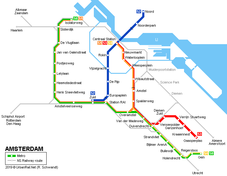
Amsterdam, the capital city of the Netherlands, has about 850,000 inhabitants (1.5 million in metropolitan area) and is famous for its huge canal system. Until 2019, the metro system in Amsterdam used to be a combination of full metro and rapid trams (sneltram) running mainly on the surface. On the original metro line, only 3.5 km runs underground in the city centre between Centraal Station and Amstel, with lines 51, 53 and 54 sharing tracks between Centraal Station and Spaklerweg. Many metro routes run parallel to NS mainline rail lines and cross-platform interchange is provided at Amstel, Duivendrecht (north-south), whereas Bijlmer ArenA, Sloterdijk, Lelylaan, Zuid, RAI and Diemen Zuid railway stations lie adjacent to the corresponding metro stations. In July 2018, the system was eventually complemented with the long-planned North-South Line (Noord/Zuidlijn), while Sneltram operation south of Zuid station ceased in March 2019 leaving a "proper" metro system.
|
|
| Oostlijn :: Centraal Station - Gein | Gaasperplas | |
|
On 16 Oct 1977 the full metro lines 53 (Gaasperplaslijn) and 54 (Geinlijn) opened between Weesperplein and Gaasperplas and Weesperplein and Holendrecht. Three years later, on 11 Oct 1980, both lines reached the Centraal Station. The 54 branch was extended to Gein on 27 Aug 1982, after Spaklerweg station had been added on 4 June 1982. Mostly 4-car trains are used on these two lines (in peak hours 6-car-trains). Both lines operate every 10 minutes, which together with line 51 means a 3/4-minute headway along the common stretch from Centraal Station to Spaklerweg. As part of the once ambitious 'metromorfose' project only Ganzenhoef station was rebuilt from concrete to glass structure.
|
|
| Ringlijn :: Isolatorweg - Gein | Centraal Station | |
|
Line 50 opened on 1 June 1997, and is fully on the surface, mainly on an embankment. Coming from the north (Isolatorweg) it joins line 51 at Station Zuid and then turns south to Gein along line 54. Apart from Sloterdijk and Lelylaan, all stations along the ring line have similar designs (see Henk Sneevlietweg picture below). On this line up to 8 cars form one train during rush hours.
|
|
| Noord/Zuidlijn :: Noord - Zuid | |
|
The 9.8 km line finally opened on 21 July 2018, with regular service starting the following day. Starting at Noord (previously referred to as Buikslotermeerplein) in the north of Amsterdam, it intersects with lines 51-54 at Centraal Station and runs under the city centre to Amsterdam's South Railway Station (Station Zuid). From Noord to the next stop at Noorderpark (formerly Johan van Hasseltweg) it runs on the surface, then continues underground for 6 km (4 km being in a 20 m deep bored tunnel) with underground stations at Centraal Station, Rokin, Vijzelgracht, De Pijp (formerly Ceintuurbaan) and Europaplein before leaving the tunnel and entering Station Zuid. Project Website
[BLOG] 5 Aug 2018: Your webmaster's impressions of Amsterdam's new Noord/Zuidlijn (including photos of all stations)
|
|
| IJtram :: Centraal Station - IJburg | |
|
Line 26 is a new express tram line, opened on 31 May 2005, that runs form the Centraal Station to IJburg, a newly built area on artificial islands in the IJmeer. It is 8.5 km long and runs on a segregated right-of-way for most of its length and in a tunnel for 1.5 km. The stop Rietlandpark is located 6 m below ground level, though uncovered, resembling a full metro station.
|
|
| History | |
|
THE BACKGROUND OF THE AMSTERDAM METRO by Philip Spangenberg  In
the early sixties the rapidly expanding city of Amsterdam (this refers
to the size of its built-up area, not to the number of inhabitants) struggled
with an insufficient public transport system. The network, mainly consisting
of tram lines, did not reach beyond the pre-war perimeter of the built-up
area. Moreover, the speed of the trams was decreasing dramatically due
to the upcoming congestion in urban traffic (as compared to present car
ownership and car use the problem seems to be of minor importance; there
were, however, far less restrictions for the use of the car than there
are nowadays). Anyhow, in 1965 the municipal government decided to replace
the tram network by a mainly underground metro network covering the whole
built-up area of the city and its suburbs. The proposed network consisted
of four lines: In
the early sixties the rapidly expanding city of Amsterdam (this refers
to the size of its built-up area, not to the number of inhabitants) struggled
with an insufficient public transport system. The network, mainly consisting
of tram lines, did not reach beyond the pre-war perimeter of the built-up
area. Moreover, the speed of the trams was decreasing dramatically due
to the upcoming congestion in urban traffic (as compared to present car
ownership and car use the problem seems to be of minor importance; there
were, however, far less restrictions for the use of the car than there
are nowadays). Anyhow, in 1965 the municipal government decided to replace
the tram network by a mainly underground metro network covering the whole
built-up area of the city and its suburbs. The proposed network consisted
of four lines:
(1) a north-south line, branching out both at its northern and its southern ends; (2) a southeast-southwest line, crossing (1) at the Central Station; (3) an east-west line, also functioning as a ring line around the city centre, crossing (1) at the Weteringcircuit and (2) at Weesperplein and at a station near Leidseplein (4) a ring line around the pre-war built-up area of the city (only half a circle, south of the IJ) Although
the north-south line coincides with the main transport axis of the city
(and for that reason could be considered as the most important and most
urgently needed line) it was decided to start with the construction
of the southeastern part of (2), for the following reasons: Construction started in the second half of the 1960s. The start coincided with the onset of the 'protest and revolt movement'. The metro itself (underground public transport means the final hegemony of the car on the street level) and the demolition of a characteristic area combined with the reduction of the cheap housing stock (very much in favour with squatters-avant-la-lettre) became an important focus of that movement. In the end the image of the metro was very negative, not only among the members of the protest generation, but among a majority of the Amsterdam population - with the exception of the alderman responsible for transport planning .... Partly due to obstruction, but mainly due to a wrong calculation of the costs, the construction of the southeastern part of the southeast-southwest line (to which the part of the east-west line serving the eastern areas of the Bijlmermeer was added as a temporary branch line) proved to exceed the budget in such a way that shortly before the opening in 1977 the national government, which in the meantime had taken over the final responsibility for urban public transport investments, decided to annul the so-called metro decree. No other metro line than the one already built (now simply referred to as the east line) would ever run underneath the surface of Amsterdam. |
|
| Suburban Rail | |
|
The Amsterdam region is served by a dense suburban rail service provided by NS (Nederlands Spoorwegen). Many stations within Amsterdam lie adjacent to metro stations, and at Amstel and Duivendrecht, cross-platform interchange between the metro and the NS trains is possible. Click here for an all-Netherlands rail map with individual services (2023).
|
|
| Metro Train | |


|
|
|
|
|
| Links | |
|
GVB - Amsterdam Public Transport Authority (Official Site) Noord-Zuid-Lijn (City Hall site) Wij nemen je mee - Noord-Zuid-Lijn Project Website Dave Pirmann's Page has hundreds of photographs on Amsterdam Transport incl. Metro Han Schomakers' page which explains colour-coding on Amsterdam metro and tram cars Amsterdam Metro at Wikipedia De Amsterdamse Metro (Wikipedia/nederlands) Amsterdam Tram & Metro Track Map at gleisplanweb.eu Alain Lemaire's Rail Amsterdam blog TRAMS 2026 - Dutch Yearbook about trams in Europe [BLOG] 5 Aug 2018: Your webmaster's impressions of Amsterdam's new Noord/Zuidlijn |
|
| Books | |
|
Robert Schwandl: TRAM ATLAS WESTEUROPA | WESTERN EUROPE - British Isles & Benelux Ireland - Great Britain - Belgium - Netherlands - Luxembourg - R. Schwandl Verlag, 10/2025, ISBN 978-3936573-81-7 |
|
 |
|
| (former) Amstelveenlijn :: Centraal Station - Amstelveen Westwijk | |
|
Line 51 was opened as a rapid tram (sneltram) on 2 Dec 1990, when it shared tracks with the Oostlijn line from Centraal Station to Spaklerweg, then part of the Ringlijn 50 to Station Zuid, before running south to Amstelveen on a separate right-of-way but with level crossings. The light rail vehicles used on this line were narrower than the metro cars, therefore they had a platform fixed to the doors to bridge the gap at metro platforms; this platform used to be folded down at Station Zuid, where also the pantograph was lifted up for overhead power supply along the street level section south to Amstelveen. As far as Oranjebaan the tracks were shared with standard tram line 5 (to Binnenhof), therefore stops had platforms with two different levels (like some German Stadtbahn networks). Some stops have an island platform. On 13 Sept 2004, a 2 km extension was added, with three new stations, Spinnerij, Sacharovlaan and Westwijk. On 03 March 2019, through operation between Metro and tram discontinued along Sneltram route between Zuid and Westwijk! Line 51 now runs from Zuid on the Ringlijn to Isolatorweg, with the Amstelveenlijn being converted to tram operation > Amsteltram [Project website]
|
|


