 Click
here to expand to full SuperVia system!
Click
here to expand to full SuperVia system!|
[ UrbanRail.Net ] [ Europe ] [ Americas ] [ Asia ] [ Africa ] [ Oceania ] [ News ] [ Books ] [ Links ] |
|
RIO
DE JANEIRO
|
| Rio de Janeiro . Brazil |
Click
here to expand to full SuperVia system!
![]()
|
METRÔ
|
|
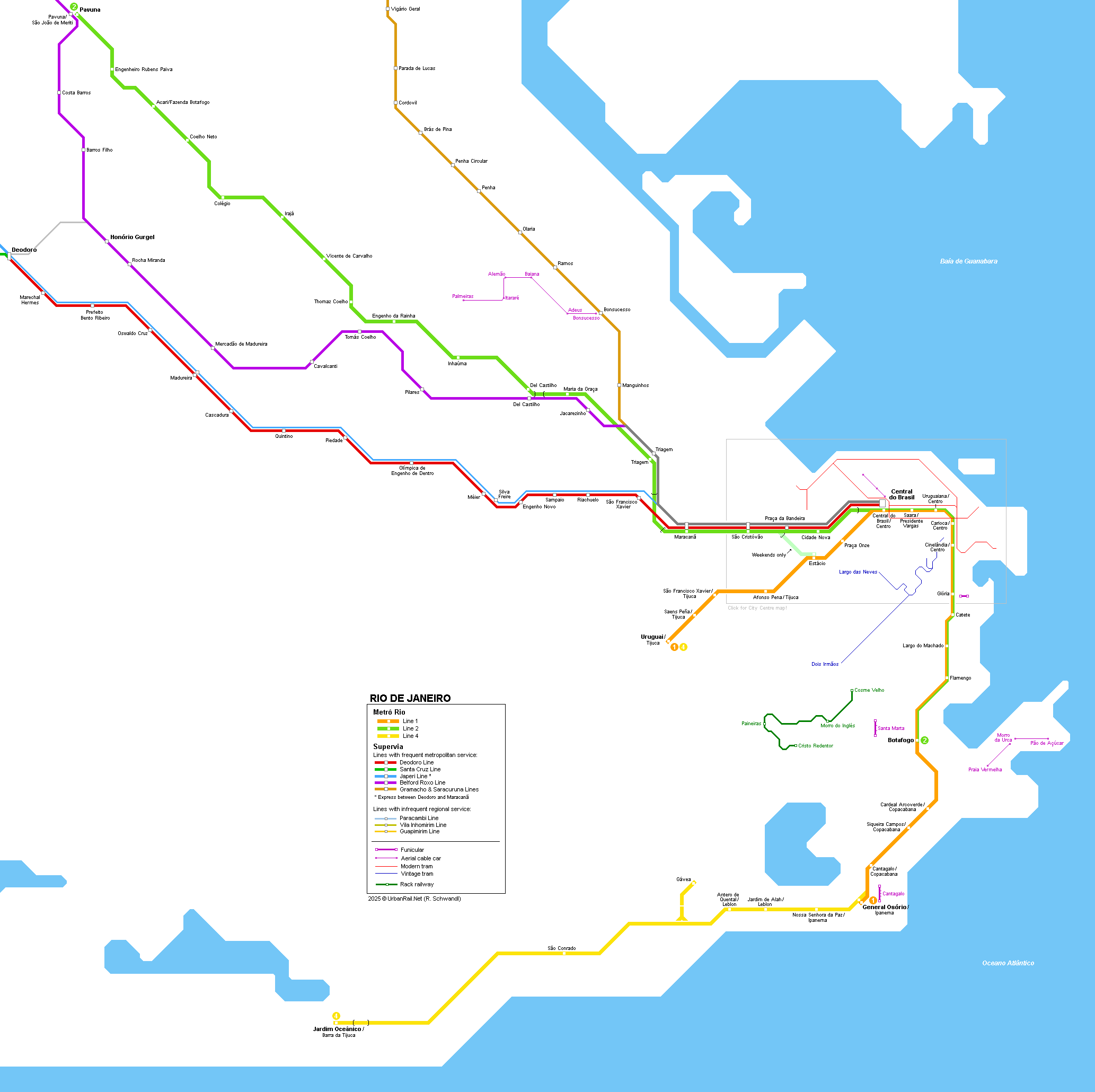
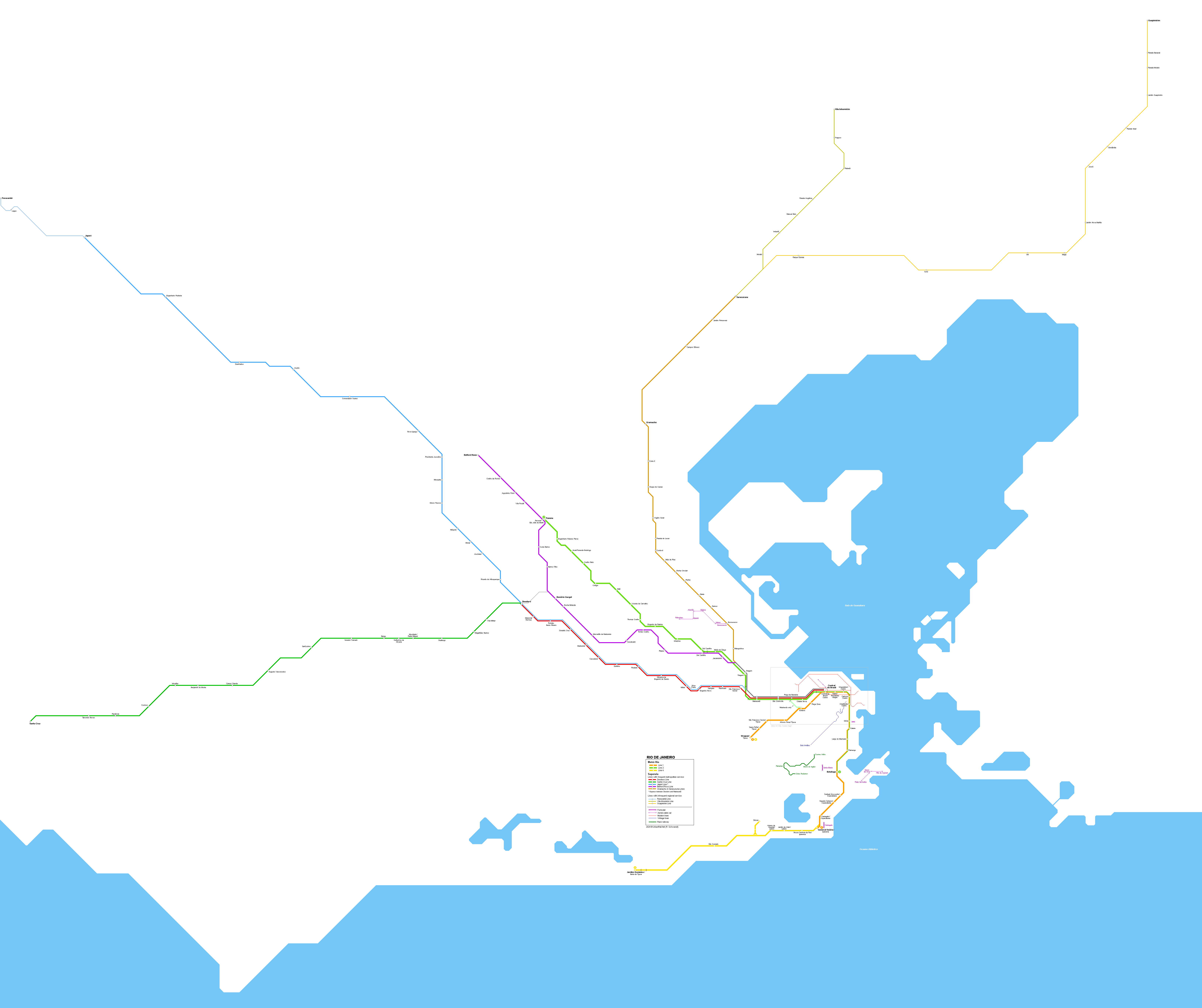
With more than 11 million inhabitants in the metropolitan area, Rio de Janeiro has a small metro network consisting of three overlapping lines. The metro network, which has 1,600 mm gauge, is complemented by several suburban rail lines (SuperVia) running north and west from the city centre.
|
| Line 1 |
|
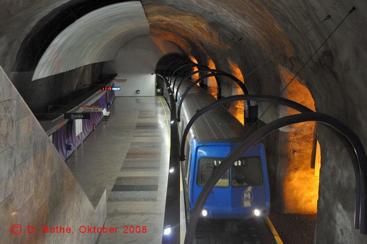
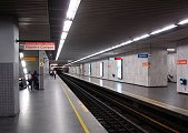
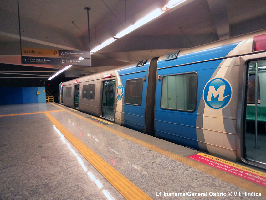
Uruguai - Ipanema/General Osório, ~19 km, 20 stations Line 1 runs from the beaches in Ipanema and Copacabana north to the city centre, then turns west via the main railway station to Estácio, where transfer used to be provided to Line 2, and further to the district of Tijuca. The first section of the line opened in 1979 between Glória and Praça Onze (5 km), after 9 years of construction. It was then extended to Botafogo in the south (1981) and Saens Peña in the west (1982). 16 years later, in July 1998 it reached Copacabana (Cardeal Arcoverde station, 1.7 km). It was extended further south to Siqueira Campos in Dec 2002, and to Cantagalo in Feb 2007. It finally reached General Osório in Ipanema in Dec. 2009. Line 1 is totally underground, uses 6-car trains, and has an average station distance of 830 m. 15 March
1979: Glória - Praça Onze (5 km) |
| Line 2 |
|
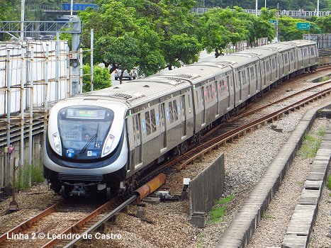
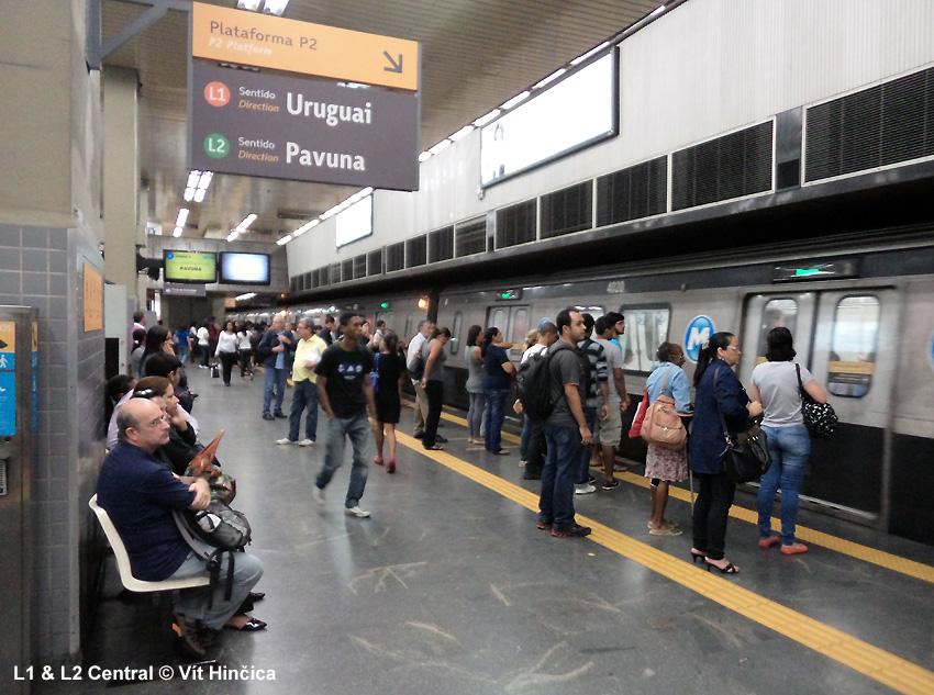
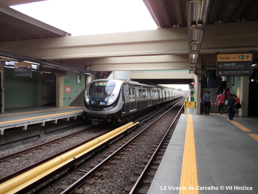
Pavuna - Botafogo, ~ 24 km, 26 stations Line 2 (partly elevated) started operating as a light rail (Premetrô) line in 1983, parallel to a suburban railway alignment, leaving from Estácio station on Line 1. Slowly and in various stages it was extended towards the northwestern districts and eventually in 1998 it reached its terminus Pavuna and was changed to full metro operation. Line 2 was once planned to be extended from Estácio into the city centre and to the harbour, crossing Line 1 again at Carioca. To relieve the interchange at Estácio, a new link was built to allow trains to continue from Line 2 directly on to Line 1 down to Botafogo. The branch diverges near São Cristóvão and runs to Central with an intermediate station called Cidade Nova. Estácio is still used as a Line 2 terminus at weekends and on holidays. 19 Nov
1981: Estácio - Maracanã (3 km) |
| Line 4 |
|
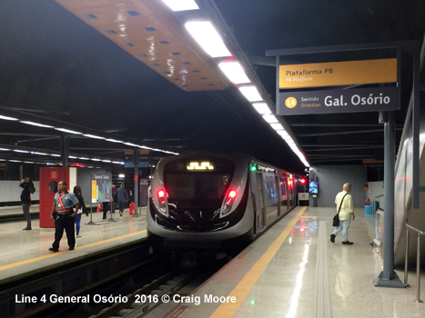
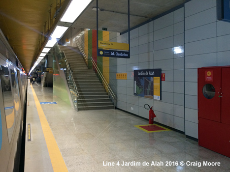
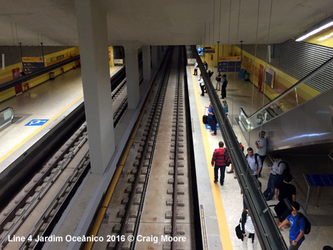
General Osório - Jardim Oceânico, ~ 13.5 km, 6 stations Line 4 connects Ipanema to Barra da Tijuca, the fastest growing neighbourhood in Rio. This line was completed in time for the 2016 Summer Olympic Games, but ran exclusively for Olympic participants until autumn 2016. 01 Aug 2016:
General Osório - Jardim Oceânico (without Gávea branch) |
|
Projects |
|
The 22 km Line 3 will be privately financed and run from Carioca station on Line 1 to Niteroi and São Gonçalo, including an underwater tunnel under Guanabara Bay. Line 6 is planned to link the International Airport on Ilha do Governador with Barra de Tijuca (22 km). It will mainly serve the northern and eastern parts of the city (Leopoldina, Baixada) and offer transfer to Line 2 and Flumitrens' suburban service. |
|
Photos
|
|
Links
|
|
Metrô Rio (Official Page) SuperVia - Suburban Trains Rio Metro at Wikipedia
|
| Photos |
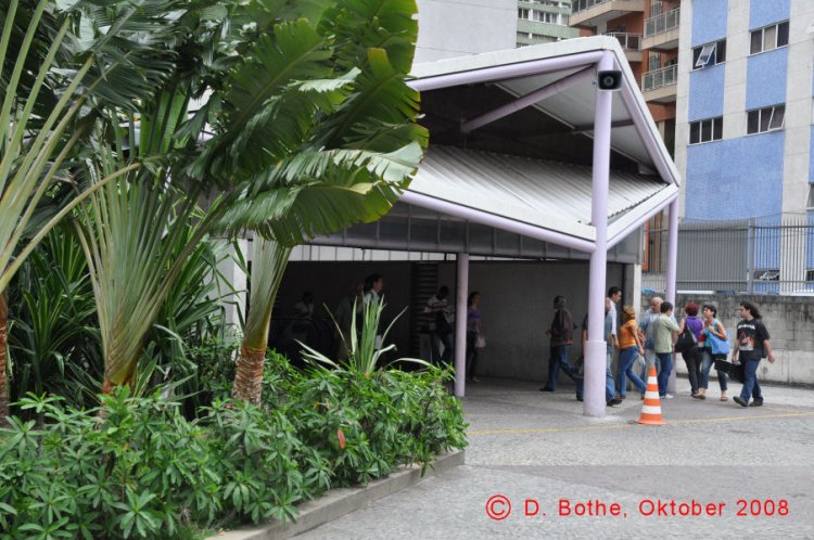
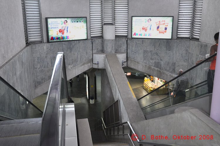
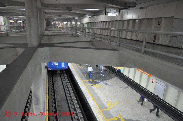

1-5 © Dietmar Bothe |
|
SUPERVIA
|
 |
| Report |
|
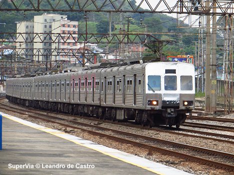
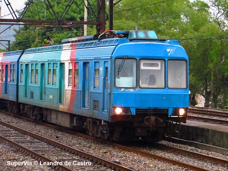
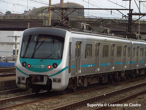
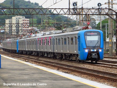
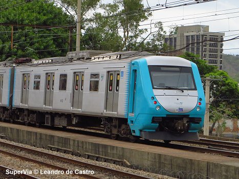
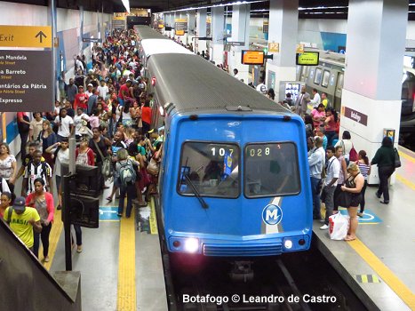
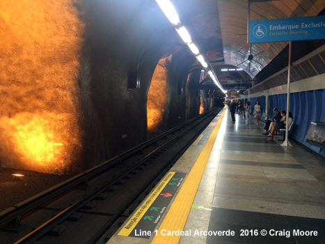
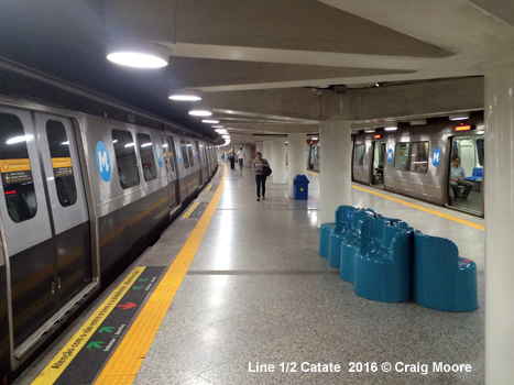
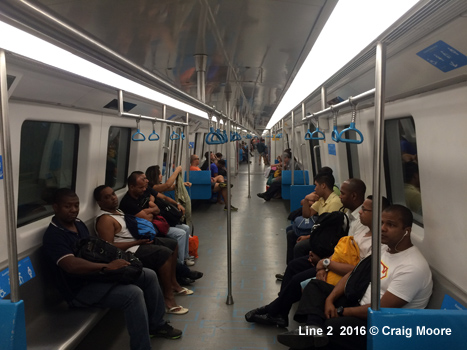
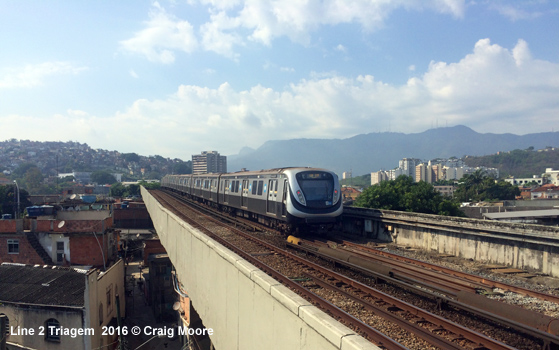
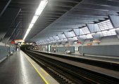
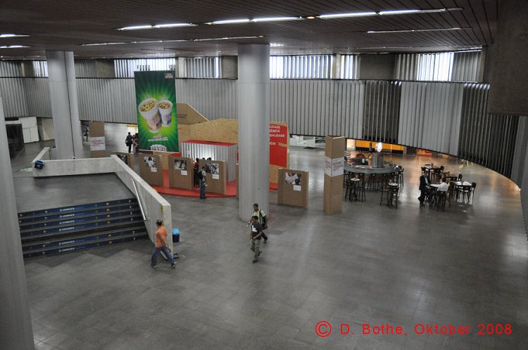
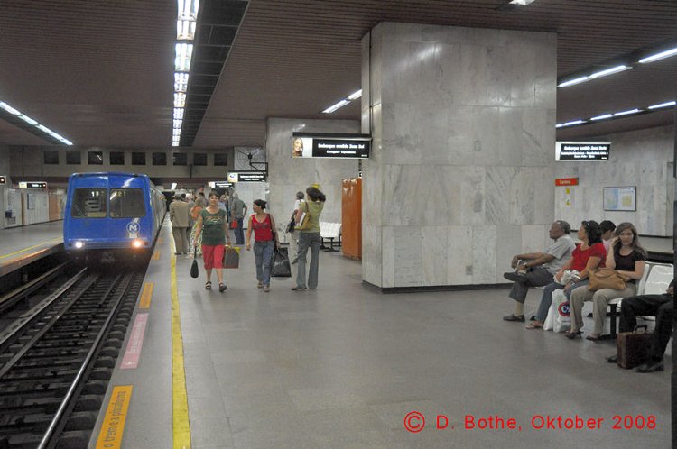
In October 2016, Craig Moore reports from Rio de Janeiro [to view Craig's Rio pictures, click here]: As one of the most characterful cities in Latin America, Rio de Janerio has an interesting mix of topographic, cultural and social features. It also offers a good range of urban rail provision. The backbone of this is MetrôRio, a three-line network of 53.8km and 41 stations running from the south-west beach area to the poorer north-west via the city centre on 1600 track (23.2km of the system lies above ground). This is certainly a system of the 1970s. With the exception of stations in the south-west, entrance halls and platforms are quite heavy, angular and concrete, with some stations, such as Carioca, noticeable overbuilt, having large, vacant mezzanines. The entrance halls are quite chaotic. Ticket machines are limited in number and are often located in distant corners, struggling to take anything but pristine bank notes. All stations, however, have a bank of centrally positioned ticket counters with very efficient staff and these are well used. Single cards (Unitário) cost R$4.10 (€1.15) and are slotted into the ticket barriers to release the turnstile. These cards are not returned from the barrier and exit from the system is via free running turnstiles. This means there is no time limit on ticket use, unlike tickets used for transfer to bus or suburban trains (90mins). At the busiest station, Central, and the main station in the commercial centre, Carioca, there are irregularly staffed information desks with limited hard copy information. The platforms are less leaden than the entrance halls, improved by colourful wall panels, illustrations and piped Brazilian music. There is a mix of side and island platforms throughout and several of the busier stations have both, enabling easy transfer and exit from either side of the train. Platforms are quite basic with very limited seating and a couple of TV screens which do not provide exact arrival times but a graphical representation of where trains are located on the line - this facility is available at underground stations only. The platforms also host system maps, vicinity maps and directional signage in Portuguese and English, provision that has recently been re-styled. It is smart, modern and tasteful and at odds with the general station surroundings but has a dark toned background, small white type and a schematic system representation with thin lines - factors that make the information quite difficult to read. Given the simplicity of the system, this does not cause too much of a problem but it is definitely a case of 'form over function'. In the main, services operate from 0500-0000 (0700-2300 Sundays) and there is a 6min base headway which is halved on the shared Line 1/2 section from Botafogo to Central. Currently there a two types of stock in use. The older stock is dated and has a flat, blue frontage and slightly different window shape at each end - trains carry 6 individual cars with no access to other carriages and seating is a mix of side and paired which are located opposite each other, alternating as you move up the carriage. There are 4 sets of very wide doors on each side of the carriage and these are topped by a strip map. Portuguese and English audio announcements are also made. Newer stock has been built CNR in China, with a metallic and black frontage which is curved and streamlined. The bright interior has stainless-steel side seating throughout and the 6 car through-trains also have very wide doors with the strip map having station lighting to show route progression. There are also TV screens located by the doors but these are for advertising only and offer no Metro information. Both types of train have women only carriages at peak periods. Line 1 (17.4km - fully underground) has 20 stations and runs from Uruguai Station to General Osório Station in Ipanema. It is the busiest line on the system and is served mainly by older stock. The beach stations beyond Botafogo have more structural presence than those in the city centre - they are more stylish and have art works and unique design features, especially the very deep Cardeal Arcoverde, which is carved out of a mountain. Its arches are floor-lit to give it a wonderful atmosphere. The terminus station, General Osório, also has smart mezzanine and platform areas. This line is quite jerky and stations in the centre are quite close together and very busy down to Botafogo and the beaches. Journey time is 40mins. Line 2 (30.4km - 6.3km is shared with Line 1) has 26 stations (10 shared with Line 1) and mainly uses the modern stock. The independent section of the line beyond Central is 24.1km in length and this part of the network is mainly elevated or at grade (1.5km of underground running in short stretches) as it heads north-west to the poorer parts of the city. The elevated sections around Irajá, Triagem and Cidade Nova offer some fantastic views of the city, mountains and favelas. The stations on this part of the line are quite basic and mainly have side platforms on which there is no 'next train' information. This line runs parallel to Supervia tracks (separated by a wall) from Central to Triagem and provides barriered interchange with the suburban rail at several points. At weekends, this line terminates in the city centre, taking the former main line (now a branch) from São Cristóvão to Estácio. Estácio is a two-level station with the Line 2 weekend platforms lying below the main Line 1 platforms (This branch is not included in any Km totals). Journey time from Central to Pavuna is 37mins. Line 4 (12.3km - fully underground except a 0.6km bridge crossing of the Tijuca inlet) runs on weekdays only from the south-west coastal area around Jardim Oceânico to the Line 1 terminus at General Osório with 8min headways. Being opened for the 2016 Olympics, the stations on this line are smart, large, clean and well designed with a mix of side and island platforms. The connection between Line 4 and Line 1 at General Osório involves a lengthy walk, a long escalator ride and passage through turnstiles (no ticket required). The line is fully independent of Line 1 and uses its own batch of CNR stock in 6-car sets. Understandably, this is the least used of the three lines and journey time is 14mins. This is quite a short metro system given the size of the city but it does function well and is also competently supported by the SuperVia Trens Urbanos network. Originating in the mid-19th century, suburban rail provision in Rio went through several phases of expansion and operational consolidation before being merged into the well branded SuperVia system in 1998. This 8-line suburban rail network is essentially 4 lines with branches or extensions; operating from 0430-2300 across and beyond Rio State which covers the immediate urban area (five Metro interchange stations) and built-up corridors as far as Santa Cruz in the west and Saracaruna in the north. The network has 101 stations and 217km of service route (94km and 58 stations in the main Rio urban area) and is therefore quite a substantial system. Lines run from the main Rio hub of Central do Brazil. This magnificent art deco station is a large rectangular space and at its western side are ticket counters, barriers and 12 platforms, lying perpendicular to the station building. Most of these platforms are single-tracked, with even numbered platforms used to board trains and odd numbered platforms for alighting. This works well in peak hour when headways are intense. Fares are distance-based and a card-ticket is issued which, like the Metro, disappears once inserted into the barrier. Although there are audio announcements in Portuguese and English, directional signage is not very clear and there are no electronic boards to show destination, platform or departure time - it is a case of walking along to see where your train is likely to go from, as platforms tend to be grouped in service clusters. Unsurprisingly hard-copy information is limited but timetable sheets are hung from platform pillars. These show most daytime headways at 15mins, although there are some hourly serviced lines. Given that all routes run as far as Maracanã, and that there are several lines operating different service patterns to Deodoro, then there are Metro-like frequencies to some areas. Deodoro, for example is served at 7/8min base frequencies and the Central-Maracanã section is served 12 times per hour. SuperVia utilises five stock types with three being modern, 8-car through trains. These are the most commonly used, the older stock serving peripheral lines. Trains use overhead power supply and have paired seating with strip maps above doors and Portuguese and English electronic and audio information. The services are well used and there is a constant flow of tradesmen selling their wares from chewing gum to selfie-sticks to brighten up the rather slow and cumbersome journeys. Indeed, the infrastructure is quite worn and very basic except for the larger stations such as Maracanã and Engenho de Dentro (an 8-platform station rebuilt for the Olympics). And so, although well branded and operationally coherent, SuperVia is not an S-Bahn-type service once you leave the inner city area. VLT do Rio de Janeiro trams began operation ahead of the 2016 Summer Olympics and run on a single line from the bus station, via the main north-south commercial avenue to Santos Dumont Airport. Services run at 15min headways and use Alstom Citadis stock. Each service is accompanied by a motorcyclist who makes sure road traffic stops at conflicting junctions. The shallow platform stations are smart with one side hosting a ticket machine, along with geographic and schematic route maps. Additionally, the heritage Santa Teresa Tram with its unique 1100 gauge is now operational again after its closure in 2011. It runs from 0800-1600 at 20mins intervals and is a free service. Running from the centre it immediately crosses the famous Lapa Aqueduct before climbing steeply up the hill to the terminus at Morro Dois Irmãos. The views are magnificent as are the traditional halts and the jerky 6km ride. |
2007 © Robert Schwandl (UrbanRail.Net)