|
Click here to expand to full size! |
|
| LIGHT RAIL | |
|
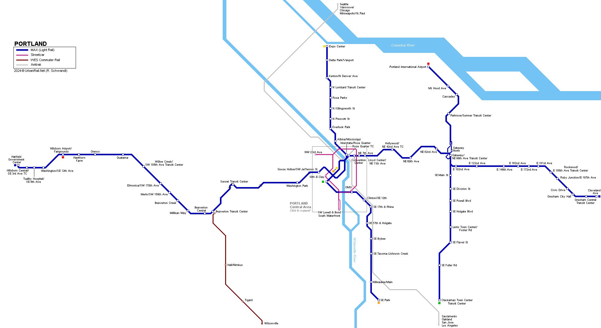
Portland
light rail system 'MAX' (Metropolitan Area Express): Blue
Line: Hillsboro - City Center - Gresham: A second downtown route (Portland Mall), served by the Yellow and Green Lines, opened on 30 Aug 2009 (3 km), with the last two stops at PSU (SW 5th & Jackson and SW 6th & College) being brought into service on 2 Sept 2012. Light Rail and Streetcar share the new bridge over the Willamette River opened in Sept 2015 along with the Orange Line. On 4 March 2024, the Red Line was doubled in the area of the Gateway junction in the east of the metro area; this was done by adding a separate flyover and an inbound-only station called Gateway North, while outbound trains continue running on the single track previously used in both directions. On 25 Aug 2024, Red Line started to continue west from Beaverton to Hillsboro Airport/Fairgrounds. The Yellow Line was once planned to be extended north across the Columbia River to Vancouver, WA, in conjunction with a new bridge for I-5. A southwestern extension of the Green Line from downtown towards Tualatin was rejected in a referendum in 2020. In 2019, proposals were issued for a downtown tunnel.
|
|
| Photos | |
|
|
|
| STREETCAR | |
|
Portland also boasts a proper streetcar (tramway) operating with modern Skoda, Inekon and United Streetcar low-floor vehicles. A 5.3 km eastside extension opened on 22 Sept. 2012 as the first stage of a loop, which was completed on 12 Sept. 2015, sharing the new bridge over the Willamette River with the Orange Line. |
|
| Photos | |
|
|
|
| Links | |
|
TriMet (Official Website) Portland Streetcar (Official Website) MAX Light Rail at Wikipedia Portland Streetcar at Wikipedia Portland Light Rail at lightrailnow.org Extensive description at nysubway.org Read your webmaster's impressions of the Portland light rail & streetcar systems (July 2012)
|
SUBWAYS
& LIGHT RAIL Click here for more info! |
| .. | |


2005 © UrbanRail.Net by Robert Schwandl