
| METRO & LIGHT RAIL | |
|
With 4 million inhabitants, Los Angeles is the centre of a metropolitan area which is home to some 18 million people within a narrow stretch of land between the Pacific Ocean and the Santa Monica and San Gabriel Mountain ranges in Southern California. After all streetcar lines had been closed down by 1963, Los Angeles became the model for a car-friendly city. Finally in the 1980's, the county and region decided to return to rail-based public transport and to build a network of metro and light rail lines. The current system has a total length of ~182 km (06/2023), with two subway lines (Red & Purple Lines) and four largely grade-separated high-floor light rail lines (Blue, Green, Gold and Pink Lines).
|
|
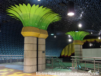
| [B] Metro Red Line | |
|
23.6 km - 14 stations
All stations boast interesting designs. Due to the city's geographical situation, tunnels had to be built to resist earthquakes up to magnitude 7.5. Rolling stock was bought from Breda (Italy); power is supplied via a third rail. From the Metro Red Line's North Hollywood terminus an exclusive right-of-way to be used by rapid bus transit was built. This 22 km route with 13 stops is promoted as the Metro Orange Line and opened on 29 Oct 2005. |
|
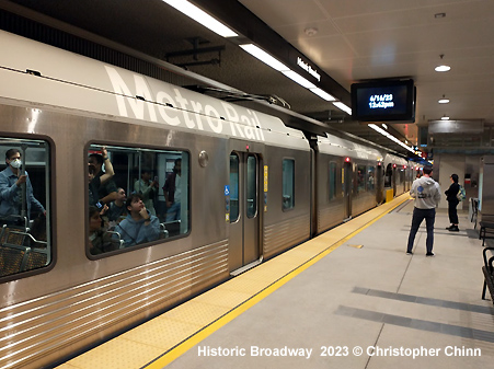
| [D] Metro Purple Line | |
|
14.2 km - 11 stations Since 2007, the former Metro Red Line Wilshire branch has been designated as the Metro Purple Line (D). It shares tracks with the Metro Red Line (B) between Union Station and Wilshire/Vermont (6.2 km), before serving five stations exclusively. The entire Metro Purple Line is underground. |
|
|
|
|
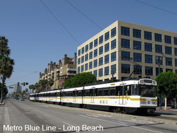
| [A] Metro Blue Line | |
|
79.2 km - 44 stations
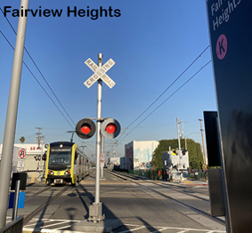
Upon completion of the 3.1 km Regional Connector on 16 June 2023, the northern leg of the former Metro Gold Line (L) was connected to the Metro Blue Line, creating a long cross-city line from Azusa and Pasadena to Long Beach, as originally planned. A northern LRT route from Union Station to Pasadena opened in July 2003 as the Metro Gold Line. It runs along a former railway corridor from Los Angeles to Claremont. It is mostly separated from road traffic with a few level crossings. At Union Station it departs from one of the former railway platforms, while the Metro Red/Purple Line departs underground. Before and after the Highland Park station, it runs at relatively low speed on a reserved lane along Marmion Way. There is a short tunnel in old Pasadena, between Del Mar and Memorial Park stations. Some 500 m beyond Memorial Park station the route gets aligned in the median of freeway I-210 up to its initial terminus at Sierra Madre Villa. The former Metro Gold Line was further extended eastwards from Sierra Madre Villa to Azuza, adding 18.4 km and 6 stations. In the next stage, another 19.8 km was to be added to bring the Metro Blue Line via Pomona to Montclair — while the first 14.7 km to Pomona North opened on 19 Sept 2025, the final segment to Montclair in neighbouring San Bernardino County was cancelled in 2025. From 24 Oct 2020 until June 2023, the former Metro Gold Line, which had reached a total length of 50.1 km, was split due to the construction of the northern access to the Regional Connector tunnel at Little Tokyo/Arts District. Visit Metro Blue (A) Line Gallery!
|
|
|
|
|
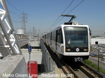
| [C] Metro Green Line | |
|
28.6 km - 12 stations
*The western leg to Redondo Beach (5.4 km) was transferred to the Metro Pink Line on 3 Nov 2024, while the Metro Green Line was extended to Aviation/Century station (1.9 km). On 6 June 2025, the Green Line was extended by 450 m to the new LAX/Metro Transit Center station. Lines C and K now share 2.2 km. |
|
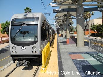
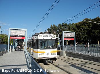
| [E] Metro Gold Line | |
|
35.4 km - 29 stations
The eastern leg of the Metro Gold Line was later opened in Nov. 2009 from Union Station towards the east, with stations at Little Tokyo/Arts District, Pico-Aliso, Boyle Heights Mariachi Plaza, Soto, Indiana, Maravilla, East L.A. Civic Center and Pomona/Atlantic. This 9.6 km route includes a short 2.7 km tunnel section with two underground stations. Construction of the former Metro Expo Line (colour aqua)line began in 2006, with the first section from downtown west to Culver City (approx. 14 km) finally opened in 2012. The underground downtown terminus was shared with the Metro Blue Line; the Expo Line branched off just south of Pico station to continue west along Exposition Boulevard. The second stage (10.6 km) brought the line to Santa Monica in 2016. Visit Metro Gold (E) Line Gallery!
|
|
| [K] Metro Pink Line | |
|
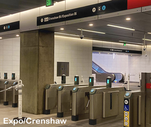
22.5 km - 13 stations - Crenshaw/LAX Line - 13.5 km light rail link between Expo/Crenshaw on the Expo Line and Aviation/LAX on the Green Line. The route was originally designed with 8 stations, with a ninth added at a later stage to provide an interchange with the under-construction people mover that will connect all the airport terminals. Construction was launched in Jan 2014, and the initial section was brought into service in Oct 2022. - On 3 Nov 2024, the former Metro Green Line section from Aviation/LAX to Redondo Beach (5.4 km) was transferred to the Metro Pink Line, while the Metro Green Line was extended to Aviation/Century station, with the K Line operating on two isolated sections until the missing middle part with the LAX transfer station was completed on 6 June 2025 (1.9 km). For more details see metro.net/projects/crenshaw_corridor |
|
|
|
|
History |
|
|
14 July
1990: Pico
Anaheim Street (31.4 km)
|
|


|
|
| Current Projects | |
|
- The final stage of the Foothill Extension will add another 5 km from Pomona North to Montclair (2028) - For more details see Foothillgoldline.org - Westside Extension - planned Purple Line extension to Westwood/VA Hospital generally following Wilshire boulevard, 14.4 km in length, with seven new stations: Wilshire/La Brea, Wilshire/Fairfax, Wilshire/La Cienega (opened May 2026), Wilshire/Rodeo, Century City, Westwood/UCLA, Westwood/VA Hospital. For more details see metro.net/projects/westside - East San Fernando Valley Light Rail - between the G Line (Orange - BRT) Van Nuys station and the Sylmar/San Fernando Metrolink station in the northwest of the metropolitan area (> 2030) [More info] For more projects click here! |
|
| STREETCAR | |
|
Los Angeles Downtown Streetcar Project OC Streetcar on UrbanRail.Net - under construction in Santa Ana, Orange County
|
|
|
|
|
| Links | |
|
Metro (MTA) - Official Page MetroLink (Commuter Rail) L.A. Metro Rail at Wikipedia Los Angeles Transit at nycsubway.org (incl. many pictures and maps) Hundreds of photos at SubwayNut Read your webmaster's comments on the Los Angeles urban rail system (Aug 2012)
|
SUBWAYS
& LIGHT RAIL Click here for more info! |


Thanks to Elson Trinidad and Yuri Popov! Thanks also to Robert Saunders at LAMTA for the help!
2004 © UrbanRail.Net by Robert Schwandl